Forest monitoring

Sensor data for condition monitoring of forests and digitalization of forestry processes

Climate change and the resulting weather extremes and pest infestations are harming our forests. The forest ecosystem is at risk – and, in turn, the quality and quantity of timber yield. The sustainable cultivation of forests depends on regular status monitoring in combination with the planting of climate change-resilient tree species, efficient cultivation of mixed-species instead of monocultures and early detection of damage. At the same time, digitally collected sensor data is the basis for a comprehensive digitalization of the forest ecosystem (digital twin of commercial forests) and the timber industry. 

We’re developing drone-borne and terrestrial monitoring systems for fast and efficient measurement of forest areas. Various sensors are integrated into the UAV/drone platforms of these optical systems. Laser scanners and cameras capture multiple parameters simultaneously, generating a constant data stream which can be automatically evaluated.

Multimodal measurements: LiDAR combined with multispectral cameras

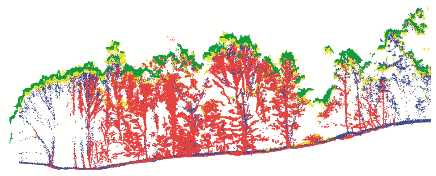
Our measurement systems consist of cameras, ultra-lightweight laser scanners and positioning units. This opens up a whole new range of possibilities for forest monitoring: Our multispectral camera systems detect vegetation from the air, providing insights into plant health (e.g. according to the normalized difference vegetation index, NDVI). Laser scanners collect 3D geometry data from which a vast amount of information can be derived: height of individual trees or entire forests, stem and crown diameters of individual trees, the number and density of trees, 3D coordinates of crowns, classification of deciduous and coniferous trees, timber volume and growth, estimated biomass volume and divisions between forest areas.  

Sensor and data fusion for comprehensive forest health characterization

For comprehensive forest status monitoring, we fuse multiple sensor data from terrestrial and drone-borne measuring systems. For the first time, this type of multimodal environment capture enables a comprehensive forest characterization, i.e. structured information on the state of a forest above and below the tree crowns.

Waldmonitoring: Automatisierte Anaylse von Messdaten
© dugdax/Shutterstock., Image montage Fraunhofer IPM
Data from multimodal sensor systems, such as LiDAR and multispectral cameras, can be automatically evaluated using AI-based methods. Fraunhofer IPM uses its specially trained deep learning framework 3D-AI to distinguish tree trunks from other vegetation, for example.

Automated evaluation of large amounts of data with deep learning

Measurement data from large areas of land is typically analyzed in an automated or semi-automated way. The 3D-AI deep learning framework developed by Fraunhofer IPM offers data evaluation with high efficiency, resolution and reliability. The point clouds that are automatically generated by 3D-AI contain RGB information, multispectral data and depth information. The data evaluation is very robust against object variations, different angles and lighting conditions.


ECOSENSE Collaborative Research Centre

Cross-scale quantification of ecosystem processes in their spatial-temporal dynamic using smart autonomous sensor networks


Fraunhofer IPM is involved in CRC 1537ECOSENSE coordinated by the University of Freiburg and the Karlsruhe Institute of Technology (KIT). The CRC is funded by the German Research Foundation (DFG).

As part of ECOSENSE, we work closely with the Department of Sustainable Systems Engineering of the University of Freiburg INATECH to develop a drone-borne LiDAR system for measuring chlorophyll fluorescence (ChlF). ChlF provides insights into the photosynthetic activities of plants to indicate how environmental changes are affecting vegetation. The LiDAR system will feature a novel evaluation chain and a special laser deflector to enable chlorophyll fluorescence to be determined across a wide area. The measurement data will be used to create detailed spatiotemporal 4D fluorescence maps of forests with resolutions all the way down to the level of individual leaves.


MuSe-3D project

Multispectral camera system surveys marshland

In the Eurostars project MuSe-3D, we teamed up with Remote Sensing Solutions GmbH to develop an ultra-lightweight camera system for drones. It efficiently captures images and 3D geometries of large areas from the air. The result of this project is an interactive 3D map of the Kochelsee marshland near Benediktbeuren, Germany.