Mobile mapping of reservoirs
High-precision 3D surveying of the Liebensteinspeicher reservoir
Dams are amongst the most closely monitored structures in Germany. However, traditional methods for surveying the basin of a reservoir are very time-consuming and produce comparatively imprecise data. On behalf of the Weiden Water Management Authority, GeoGroup GmbH and Fraunhofer IPM have now conducted a survey of 100 percent of the Liebensteinspeicher reservoir in Germany’s Upper Palatinate region. The resulting high-precision 3D data provides insights into the reservoir volume, the water table area and the depth of the lake.


Reservoirs can do many things: They protect people from flooding, facilitate river and stream runoff in dry conditions, generate energy, provide a habitat for flora and fauna and sometimes even supply drinking water. That said, trapping so much water also poses certain dangers. This is why strict regulations are in place for such structures, and operators must conduct regular, in-depth inspections. Thanks to new measurement techniques, it has now become possible to collect high-precision 3D data on the condition and volume of reservoirs.
Liebensteinspeicher: full survey with echo sounder and LiDAR
A Fraunhofer IPM and GeoGroup GmbH project team combined multiple high-end measurement techniques when conducting a full survey of the Liebensteinspeicher reservoir to produce a 100-percent image of the bottom of the lake. For the surveying, GeoGroup used a mobile mapping system fitted with echo sounder mounted on a boat. At the same time, Fraunhofer IPM used its Lightweight Airborne Profiler (LAP) to fly over the lake. The measurement system consists of a laser scanner, several cameras and a positioning sensor, which are all very light and can be fitted to a drone.
High-precision data thanks to the combination of two systems
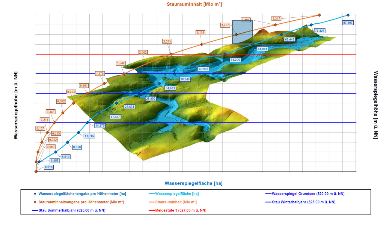
Combining these two measurement systems presents several advantages. Surveying on the water and from the air allows for precise measurements of even the most inaccessible places, such as steep embankments or overgrown areas. “In the past, we may have been able to obtain four measuring points – thanks to this new method it’s four million,” explains Timo Schröder, project manager at GeoGroup GmbH. “What’s more, the datasets from both systems overlap. This has enabled us to produce particularly accurate calculations.” The fused data is the basis for a 3D model of the reservoir, several maps of the water table area and regarding the depth of the lake as well as the filling level curve.